

Newsroom
-
 Advances in Nanosecond Laser Research Power up Equipment Development
China's laser equipment development for space debris detection as well as Thomson scattering diagnostic of plasma have achieved progresses, thanks to the recent advances in nanosecond laser technology, according to the Aerospace Information Research Institute (AIR), Chinese Academy of Sciences (CAS).
29 Jul 2022 -
 SDGSAT-1 Starts On-orbit Scientific Service
On July 18, China's Earth Science Satellite called Guangmu, or SDGSAT-1, after 6-month on-orbit testing phase, was officially delivered to the International Research Center of Big Data for Sustainable Development Goals (CBAS), marking the start of its on-orbit scientific services.
27 Jul 2022 -
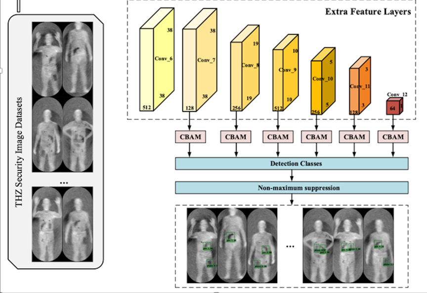 Deep Learning Technology Enables Terahertz Security Inspection More Accurate and Faster
A research team led by Prof. FANG Guangyou from the Aerospace Information Research Institute (AIR), Chinese Academy of Sciences (CAS) trained and tested a promising detector based on deep residual networks using human image data collected by passive terahertz devices (Figure 1a, b, c). The proposed new method can be used for accurate and real-time detection of hidden objects in terahertz images. The study was published in Scientific Reports.
22 Jul 2022 -
Book Series "BeiDou Navigation Satellite System" Compilation Underway
An editorial committee meeting was held in Beijing on July 1, 2022, marking the inauguration of compilation of the book series BeiDou Navigation Satellite System (BDS) , which aim to wrap up how the BDS was constructed in China as well as its achievements.
17 Jul 2022 -
 Scientists Propose Flexible THz Carrier-Envelope Phase Shifter Based on Metamaterials
A research team led by Prof. WANG Tianwu from the Aerospace Information Research Institute (AIR), Chinese Academy of Sciences (CAS) proposes an ultra-thin THz CEP shifter composed of different MM arrays, which can modulate the CEP of broadband THz pulses in the sub-wavelength thickness range and maintain the electric field polarization (Figure 1a, b). The study was published in Advanced Optical Materials.
14 Jul 2022 -
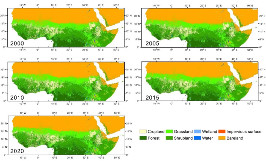 Datasets Unveil Impacts of Land Use and Cover Change on Sahel in Africa
Four datasets on the Sahel-Sudano-Guinean region of Africa have been recently released on the platform of the National Tibetan Plateau / Third Pole Environment Data Center. The four datasets include: 1) 30m resolution land use/cover the (1990-2020); 2) annual NPP-VIIRS (National Polar-Orbiting Partnership - Visible Infrared Imaging Radiometer Suite) night time light (2013-2020); 3) long time series on night time light on the same region as data set (2), but a much longer period of time (1992-2020); 4) inventory and extent of surface water bodies (2000-2020).
06 Jul 2022

