

Newsroom
-
 China-developed Knowledge-guided AI Algorithm Offers Promising Results in Global Soil Moisture Management
Researchers from the Aerospace Information Research Institute under the Chinese Academy of Sciences (AIRCAS) have developed a knowledge-guided artificial intelligence algorithm that significantly improves the resolution of global soil moisture observation.
09 May 2026 -
 Unified Weakly Supervised Learning Framework Advances LiDAR Remote Sensing for Earth Observation
A research team from the Aerospace Information Research Institute of the Chinese Academy of Sciences (AIRCAS), in collaboration with Changsha University of Science and Technology, and Tsinghua University, has proposed a systematic and unified framework that integrates Light Detection and Ranging (LiDAR) remote sensing with Weakly Supervised Learning (WSL). The study provides a comprehensive review that bridges the traditional gap between LiDAR data interpretation and large-scale parameter inversion, offering scalable solutions to reduce the high costs of manual data annotation in Earth observation.
30 Apr 2026 -
 China's Fengyun Satellites Enable Breakthrough in Mapping Underground Soil Temperatures Worldwide
A recent study published in the ISPRS Journal of Photogrammetry and Remote Sensing, describes a physics-based framework that maps global subsurface soil temperature profiles by harnessing the multi-overpass capabilities of China's Fengyun (FY) meteorological satellites. This work was led by Prof. ZHAO Tianjie from the Laboratory of Earth Observation for Water at the Aerospace Information Research Institute of the Chinese Academy of Sciences (AIRCAS).
27 Apr 2026 -
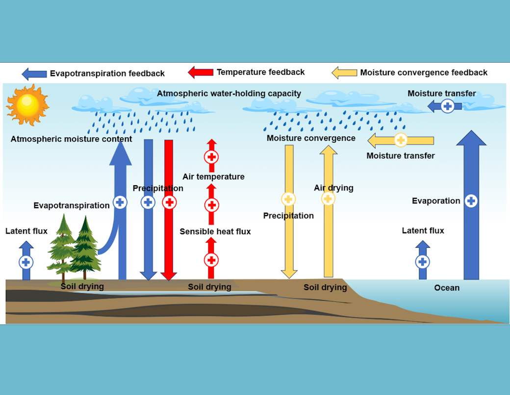 Half the World Is Drying, but Not as Models Predict: New Global Soil Moisture Study
A research team led by Prof. WANG Shudong at the State Key Laboratory of Remote Sensing and Digital Earth, Aerospace Information Research Institute, Chinese Academy of Sciences (AIRCAS), has made significant progress in reconstructing long-term global surface soil moisture variations and improving future projections through observation-constrained climate modeling. The study, Quantifying Historical and Future Surface Soil Moisture Drying Using Deep Learning and Remote Sensing, was recently published in Earth's Future .
31 Mar 2026 -
 Global Map Reveals One-third of World's Forests Disturbed in Two Decades
In a study published in Earth System Science Data, an international research team has created the first high-resolution global dataset of forest disturbance types, ---the Global Forest Disturbance Type Dataset (GFD), showing that 31% of the world's forest area, approximately 1.247 billion hectares, experienced disturbances between 2000 and 2020.
31 Mar 2026 -
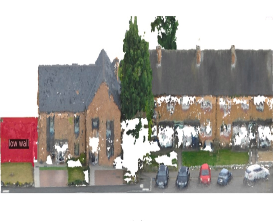
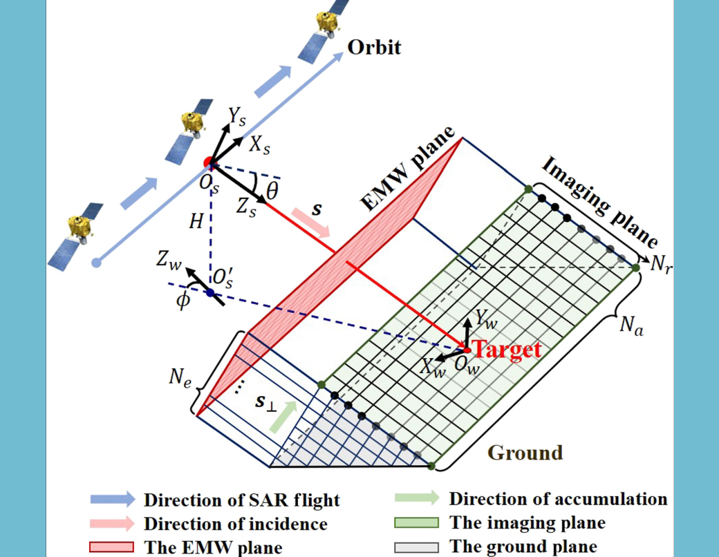 Seeing Inside Radar Images: New Method Reveals 3D Origins of Bright SAR Signals
A new SAR interpretation method helps reveal the specific sources on three-dimensional targets that correspond to strong radar scattering in SAR images. By combining a customized differentiable Synthetic aperture radar (SAR) simulator with inverse optimization, the approach links bright scattering patterns in 2-dimensional (2D) SAR images to specific 3-dimensional (3D) structures. The method could improve target analysis, image interpretation, and physically grounded SAR simulation in remote sensing.
30 Mar 2026

