New Satellite Mapping Reveals Vast Undetected Trees in Tropics, Highlighting Overlooked Losses
A recent study published in Nature Communications unveils that 17.31% of tropical tree cover—equivalent to 395.9 million hectares (Mha)—has been consistently overlooked by global forest monitoring systems. Using high-resolution satellite imagery (<5m) and an advanced automated algorithm, an international research team mapped previously undetected tree cover (PUTC) across pan-tropical regions from 2015–2022. Their findings highlight significant net losses and critical blind spots in current forest conservation efforts.
The research, led by Professor WANG Li from the State Key Laboratory of Remote Sensing and Digital Earth at the Aerospace Information Research Institute (AIR) of the Chinese Academy of Sciences, found that pan-tropical tree cover decreased by a net 61.05 Mha during the study period. Losses occurred not only in forests (63.93%) but also in non-forested areas like farmlands, grasslands, and cities (36.07%). Crucially, regions with high PUTC—where trees exist outside traditional forests—experienced the most intense changes, exposing limitations in commonly used 10-m resolution datasets like World Cover.
The analysis showed a gross loss of 67.24 Mha (2.94%) of tree cover, dwarfing gains of just 6.19 million hectares. Brazil, Indonesia, and the Democratic Republic of Congo suffered the heaviest losses. Driving these changes, 43.98% of tree gains were linked to increased rainfall, while human activities (logging, land conversion) caused 56.03% of losses, with land-use changes like deforestation accounting for 53.93% of total declines.
"Neglecting scattered trees has led to systematic underestimation of ecological degradation," said lead author Dr. LIU Shidong at AIR. "Our maps show these trees buffer climate change and support livelihoods. Their loss jeopardizes carbon storage and resilience."
The study raises concerns that overlooking PUTC undermines global climate and conservation pledges like the Glasgow Declaration from COP26, in which 141 nations committed to halting deforestation by 2030. Current restoration efforts, such as the Bonn Challenge, are also falling short—pan-tropical gains between 2015 and 2022 amounted to just 6.19 Mha (2015–2022), far below global targets.
To conduct the analysis, the team developed a machine learning algorithm capable of automatically identifying tree crowns across diverse landscapes using 5-m resolution Planet satellite imagery. Validated with 150,000 ground-truth points, the model achieved an accuracy of 97.31%, marking a significant improvement over existing approaches.
"Fine-scale mapping is essential for credible climate mitigation," emphasized corresponding author Professor WANG Li. "Policymakers must integrate non-forest trees into conservation strategies to combat degradation and biodiversity loss."
The study was a collaboration between researchers from the France's Climate and Environmental Sciences Laboratory, University of Copenhagen, Spain's Global Ecology Unit CREAF-CSIC-UAB, Humboldt University of Berlin, University of Chittagong, Tsinghua University, and China University of Geosciences (Beijing).
The data from the study is available via Zenodo.
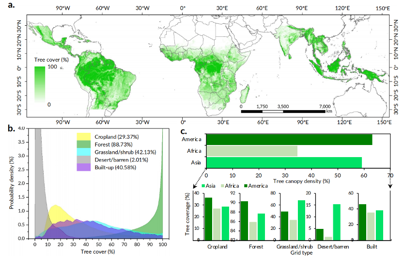
Pan-tropical high-resolution tree cover map. (Image by AIR)
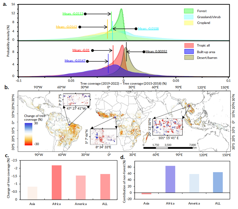
Pan-tropical high-resolution tree cover change map. (Image by AIR)
News & Events