Scientists Develop GLOSTFM: A Breakthrough Model for High-Resolution Global Land Surface Temperature Monitoring
A research team led by Professor MENG Qingyan from the Aerospace Information Research Institute (AIR) of the Chinese Academy of Sciences (CAS), in collaboration with domestic and international institutions, has successfully developed GLOSTFM, a high-efficiency spatiotemporal fusion model based on multi-source satellite data. By integrating thermal infrared and microwave observations from the Fengyun-3D (FY-3D) satellite, GLOSTFM significantly enhances the spatiotemporal resolution of land surface temperature (LST) data, providing a powerful tool for global climate change studies and urban heat island monitoring. The research findings have been published in the Remote Sensing of Environment.
LST is a crucial indicator for studying climate change, ecosystems, and human health. However, traditional remote sensing technologies face limitations due to the insufficient spatiotemporal resolution of single sensors and cloud cover interference, often resulting in data gaps or reduced accuracy. For instance, optical sensors (e.g., Landsat) capture high-resolution images but are hindered by cloud cover and long revisit cycles, while microwave sensors (e.g., MWRI on Fengyun-3D) can penetrate clouds but have lower resolution. The challenge of fusing multi-source data to generate continuous, high-precision global LST products has long been a key issue in the field of remote sensing.
At the heart of GLOSTFM is an innovative approach that combines the "image pyramid" principle with the strengths of multi-source satellite data. This technique layers high-resolution thermal infrared imagery (e.g., 1 km resolution) with low-resolution but all-weather microwave data, gradually merging them to produce a high spatiotemporal resolution global LST product. Leveraging the daily revisit capability of Fengyun-3D, the model also uses microwave data to fill in cloud-covered areas, significantly reducing data loss.
The research team tested GLOSTFM across five representative global regions, including major cities such as Beijing and Shanghai and agricultural zones in Australia, yielding remarkable results.
The fused land surface temperature data produced by GLOSTFM is highly accurate. Tests show that the model's temperature estimates are, on average, only 2.87 K off from real-world measurements. Additionally, the data has a correlation coefficient (R²) of 0.98, meaning it closely matches actual observations, making it a reliable tool for climate and environmental studies.
GLOSTFM is remarkably efficient, processing 648 million pixels of global data in just 25 minutes. This is dozens of times faster than traditional models, making it possible to handle large-scale data in near real-time for the first time.
The urban heat island effect in Beijing has been successfully tracked, revealing a significant expansion of heat-affected areas during extreme temperature events. These insights can help guide urban planning, green space development, and climate adaptation strategies, contributing to more sustainable and resilient cities.
By resolving the trade-off between high resolution and broad coverage in land surface temperature monitoring, this technology provides high-precision data that supports climate modeling and carbon neutrality efforts.
Beyond urban applications, its capabilities extend to precision agriculture, wildfire risk assessment, and ecosystem monitoring, enhancing environmental sustainability through data-driven decision-making.
Despite its breakthroughs, the team aims to further optimize GLOSTFM by integrating more satellite datasets, such as the European Sentinel series, to enhance performance under complex weather conditions. "In the future, this technology could become a fundamental infrastructure for global environmental monitoring, providing a powerful data tool for tackling climate change," said Professor MENG Qingyan.
To facilitate further research, the GLOSTFM algorithm and test datasets will be open sourced on GitHub following peer review, allowing global researchers free access to this technology.
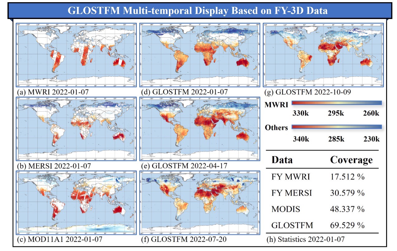
GLOSTFM multi-temporal display based on FY-3D data. (Image by AIR)
News & Events