High-Resolution Population Mapping Achieved for Greater Bay Area with SDGSAT-1 Imagery and Deep Learning
A new study published in the International Journal of Digital Earth on October 20 utilizes the advanced capabilities of the Sustainable Development Science Satellite-1 (SDGSAT-1) to produce an unprecedented high-resolution population map of the Guangdong-Hong Kong-Macao Greater Bay Area. Researchers from the Aerospace Information Research Institute (AIR) under the Chinese Academy of Sciences employed SDGSAT-1’s innovative glimmer imaging and advanced deep learning techniques to deliver a more accurate population distribution at a fine scale, offering valuable insights for urban planning, disaster preparedness, and sustainable development.
As urban regions worldwide experience rapid growth, accurately understanding population distribution is essential for effective planning and resource allocation. Traditional mapping methods often lack the resolution needed for nuanced applications in high-density urban settings. This study addresses this gap by leveraging SDGSAT-1’s 40-meter spatial resolution data alongside a newly developed deep learning model called FinePop-net, which significantly enhances population mapping accuracy.
"SDGSAT-1's glimmer imager has allowed us to view population distribution patterns at a resolution previously unattainable," says Dr. DUAN Haoxuan, the lead author. "This level of granularity is a game-changer, particularly for densely populated areas like the Greater Bay Area, where detailed data can inform everything from transport infrastructure planning to emergency response."
The researchers developed a deep learning model called FinePop-net, specifically optimized to work with SDGSAT-1 data, which brings higher spectral resolution and accuracy than commonly used nighttime light (NTL) sources. The model showed significant improvements in accuracy, reducing average error rates by over 30% compared to standard NTL-based population datasets. These improvements underscore the potential for SDGSAT-1 data to set a new standard in high-resolution population mapping.
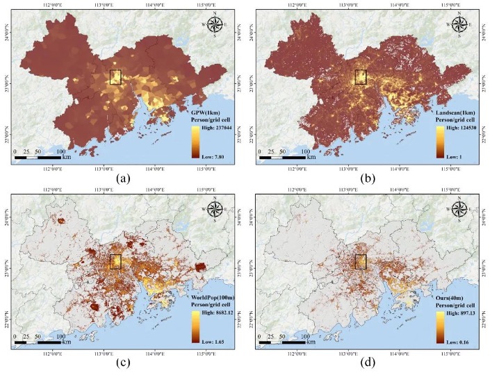
The population map created through this research provides a detailed breakdown across the Greater Bay Area at a 40-meter resolution, facilitating targeted analysis for critical tasks such as determining optimal locations for healthcare facilities and efficiently planning emergency responses.
By combining high-resolution imagery with deep learning, this research highlights the untapped potential of Earth observation in driving informed decision-making for cities globally.

Detailed Spatial Patterns of Population Distribution in the Guangdong-Hong Kong-Macao Greater Bay Area. (Image by AIR)


News & Events