Space Observation Offers Insight into Sustainability of World Heritage Sites Along the Silk Roads
A research team led by Prof. CHEN Fulong from the Aerospace Information Research Institute (AIR) under the Chinese Academy of Sciences has been using satellite imagery and deep learning techniques to monitor a UNESCO World Heritage Site---Silk Roads: the Route Network of the Chang'an-Tianshan Corridor. Their recent study, published in theInternational Journal of Digital Earth on September 13, emphasizes the growing need for vigilant monitoring as these sites face increasing threats from both urban development and natural disasters.
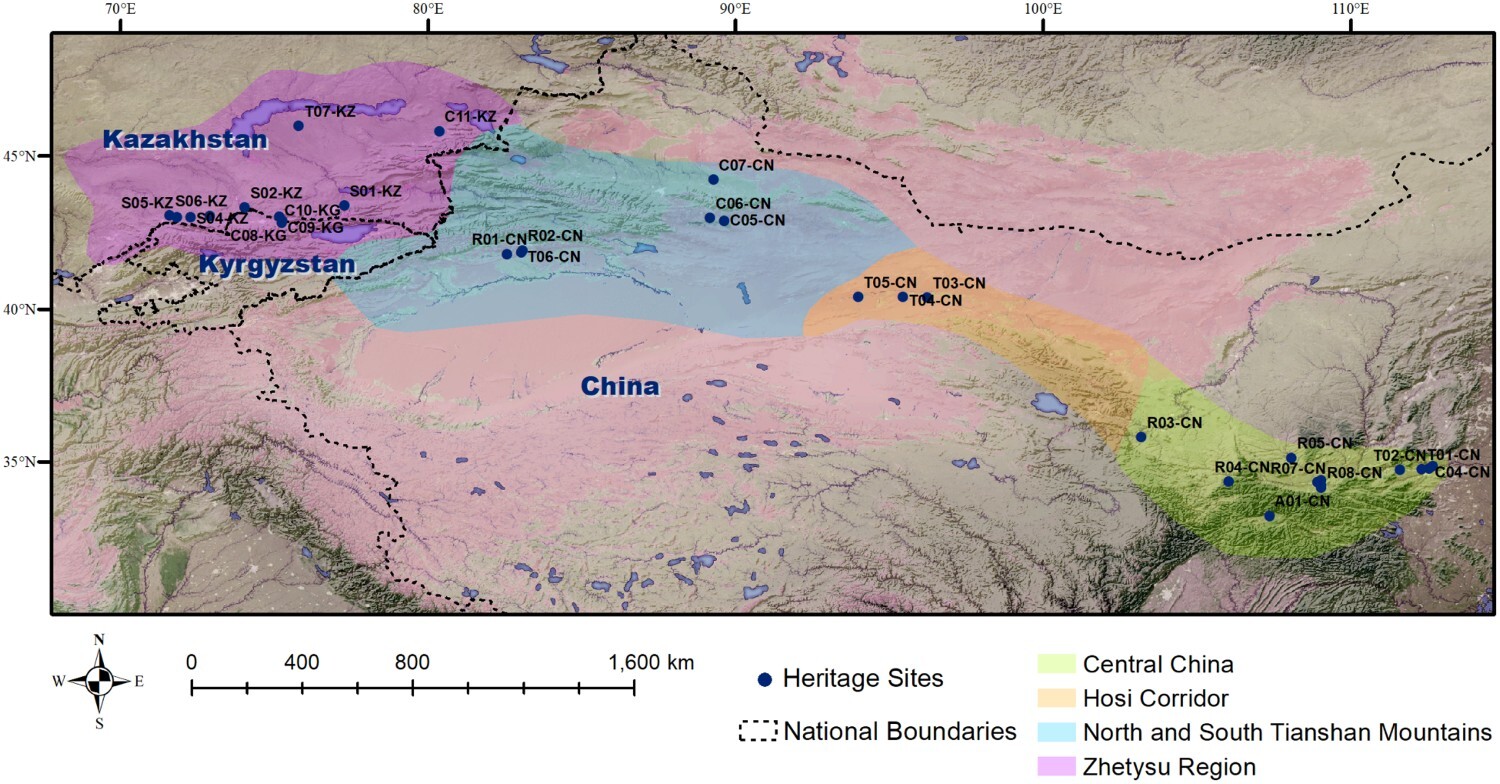
In 2014, the Chang'an-Tianshan Corridor, a major artery of the historic Silk Road that facilitated trade between China and the West, became the first segment of the Silk Road to be inscribed on the UNESCO World Heritage List. Spanning approximately 5,000 kilometers across China, Kazakhstan, and Kyrgyzstan, this trans-boundary trading route was actively used from the second century BC until the 16th century, linking cities, peoples, and cultures across Central Asia.
The research team implemented dynamic monitoring and risk assessment techniques to identify potential threats to these heritage sites. Utilizing high-resolution satellite data, they analyzed land use changes to detect human interference within the protected areas. The study employed an object-based deep learning method to pinpoint changes and instances of interference, providing a detailed analysis of how urbanization impacts heritage conservation.
In addition to land use analysis, the team examined nighttime light changes to evaluate socio-economic development in the regions where these heritage sites are located. This data was cross-referenced with the human interference findings to better understand the relationship between urban development and heritage conservation. Environmental and climate variables were also extracted to evaluate flood risks, resulting in a comprehensive risk assessment model.
The study found that while most heritage sites along the Silk Roads remain well-preserved, there has been a significant increase in construction land around them, indicating challenges in balancing heritage conservation with economic development.
The research underscores the importance of vegetation coverage and water management in preventing flooding, using space observation to identify risks. It highlights that 24% of heritage sites along the Silk Roads are at high risk, with Central China and the Zhetysu Region of Kazakhstan being particularly vulnerable due to factors like precipitation and low-lying terrain, and these risks are exacerbated by climate change.
Moreover, the research identifies the development of heritage parks and urban expansion as primary drivers of land use changes, reflecting a dynamic phase in the development and utilization of cultural landscapes at the Silk Roads.
"We've demonstrated how space observation can be a powerful tool in safeguarding our shared cultural heritage," said TANG Yunwei, the study's lead author. "By combining advanced satellite imagery with deep learning, we can provide valuable data to support the sustainable management and protection of these irreplaceable sites, aligning with global efforts to achieve Sustainable Development Goals."
This study underscores the need for constant vigilance and innovative approaches in heritage conservation. Integrating space observation with cultural heritage management not only provides a robust scientific foundation for the preservation of the Silk Roads but also fosters collaborative efforts between China, Kazakhstan, and Kyrgyzstan in heritage protection.

The distribution of heritage sites of the Silk Roads. (Image by AIR)


News & Events