Scientists Develeop First 30-m Global Map of Tidal Flats
Oct 16, 2023
The first global 30-m map of global tidal flats (GTF30) was developed by a research team led by Prof. LIU Liangyun from the the Aerospace Information Research Institute (AIR) of the Chinese Academy of Sciences (CAS). The study was published in “Journal of Remote Sensing”.
Tidal flats are usually defined as the tidal flooding zone area between the low and high tides of a coastal spring tide, are an important part of coastal ecosystems and play an important role in shoreline protection and biodiversity maintenance. Although great efforts have been made in tidal flat mapping, an accurate global tidal flat product covering all coasts globally is still lacking and urgently needed.
The 30-m map “has filled the data gap of tidal flat products in high latitides and further improved the tidal flat mapping accuracy”, said Prof. Liu.
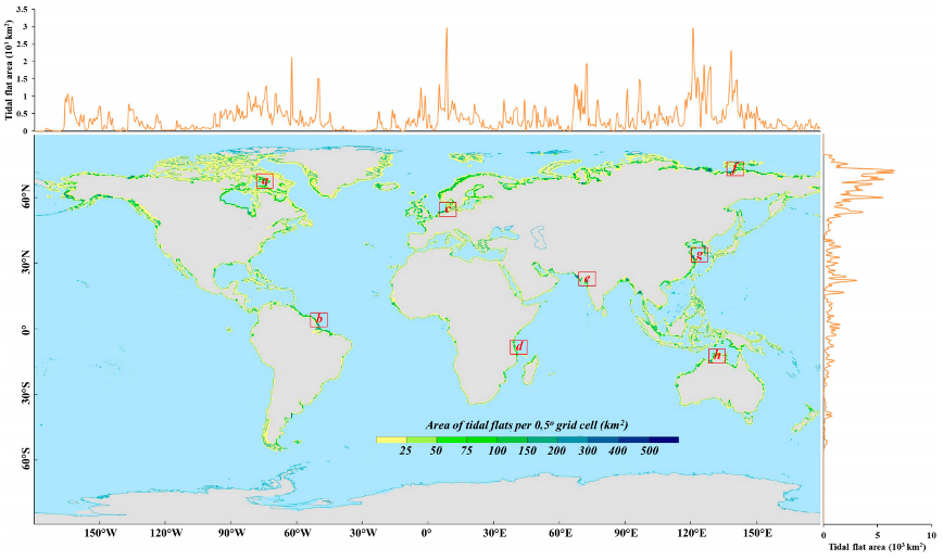
The study shows that the total global area of tidal flats is about 140,922.5 km2, with more than 75% distributed on three continents in the Northern Hemisphere, especially in Asia (approximately 43.1% of the total).
This study proposes a new spectral index named the LTideI index through a sensitivity analysis, which is robust and can accurately capture low-tide information. Then, globally distributed training samples are automatically generated by combining multisource datasets and the spatiotemporal refinement method.
Next, the global coasts are divided into 588 5°×5° geographical tiles, and the local adaptive classification strategy is used to map tidal flats in each 5°×5° region by using multi-sourced training features and the derived globally distributed training samples. The accuracy assessment achieves 90.34%, and performs better ability to identify complicated tidal flats over various environments.
The novel method can support automated mapping of tidal flats, and the GTF30 dataset can provide scientific guidance and data support for protecting coastal ecosystems and supporting coastal economic and social development. The GTF30 tidal flat dataset in 2020 is freely accessible via https://doi.org/10.5281/zenodo.7936721.

The spatial distribution of global tidal flats and their longitude and latitude statistics. (Image by AIR)
Contact: luyq@aircas.ac.cn


News & Events