Reservoir Inventory for China in 2016 and 2021 Released
Sep 20, 2023
Reservoir inventories are essential for investigating the impact of climate change and anthropogenic activities on aquatic ecosystem changes. Multi-temporal satellite data can track the change of reservoirs at large scale and provide reference for evaluation the efficiency of water resource management.
About 10.32% of the reservoirs have increased storage capacity from 2016 to 2021, while 22.73% have decreased, and most provinces and river basins in China have expanded their accumulated storage capacity from 2016 to 2021, according to a study published on September 9 in Scientific Data.
This study, based on an inventory of medium and large reservoirs in China, is carried out by researchers from the International Centre of Big Data for Sustainable Development Goals (CBAS) and the Aerospace Information Research Institute (AIR) under the Chinese Academy of Sciences (CAS), and other universities.
2016 is the year that Chinese government released Regulations on Farmland Water Conservancy to encourage the use of reservoirs for irrigation. In 2021, the Chinese National Development and Reform Commission announced to double the budget to reinforce the hazardous reservoirs.
The researchers generated the reservoir dataset over China in 2016 and 2021 by classification based on annually composited Landsat images from Google Earth Engine together with geological datasets of the National 1:250,000 Public Basic Geographic Database of 2019, and reservoir locations acquired from Baidu Maps, etc. The dataset gives a national medium and large reservoir extent of 23314.00 and 24888.95 km2 in 2016 and 2021 respectively, with the spatial resolution of 30 m, and an overall accuracy of 99.71%.
The data can be accessed here.
Study found that the accumulated reservoir storage capacity in 2016 increased with the irrigated cropland area in most agricultural regions. Notably, the accumulated large reservoir storage capacity of South China and Yunnan-Guizhou Plateau agricultural regions decreased significantly, while the irrigated cropland area increased during the study period.
The reason for South China case mostly attributes to the droughts in 2021 and the significant improvement of water use efficiency achieved in Guangdong province through continuous optimization of water use structure, according to the study.
Based on the reservoir inventories, this study not only explores the spatial distribution pattern, evaluates storage capacity change of medium and large reservoirs, as well as the irrigation cropland area change, but also advances research in other water resource utilization-related research by providing reservoir inventories in two different time domains.
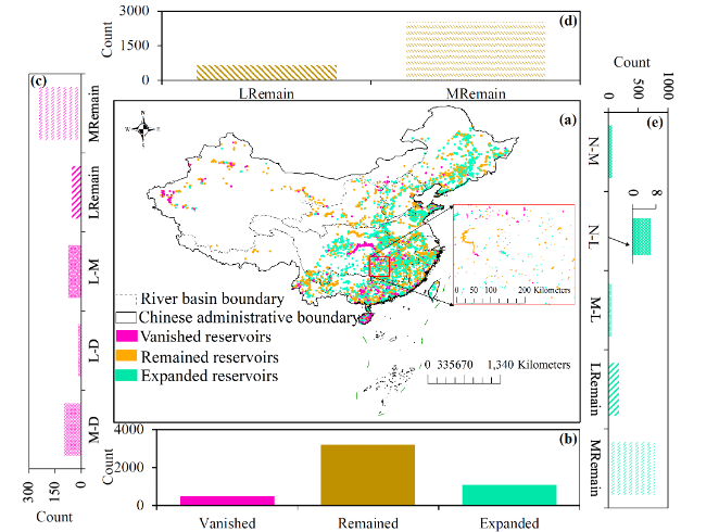
Comparison of reservoirs across China between the years 2016 and 2021. (Image by AIR)
Contact: luyq@aircas.ac.cn
News & Events